Areas close until June to help bald eagles get their groove on

Each year the famous bald eagle has a friend in the Arizona Game and Fish Department. The bald eagle is the official bird of the United States and is most recognizable by its white head and tail standing out from its otherwise brown body. Interestingly, the females are larger than males and both have an average wingspan near seven feet.
Although they are no longer listed as an endangered species, the eagles still have help from the state to manage their breeding season, which begins in December and ends in June. Like human snowbirds, bald eagles typically are found in the NW and migrate to Arizona in the winter.
Some areas that are affected by closures include Alamo Lake, Lake Pleasant,Verde River, Tonto Creek, Salt River, Becker Lake, Crescent Lake, Luna Lake, Lynx Lake, Lower Lake Mary, Greer Lakes, Woods Canyon Lake.
For detail on exactly what parts of those areas should be avoided please visit the full listing on AZ Game and Fish Department's website.
There are 52 breeding pairs of eagles in Arizona (more than 7,000 in the U.S as a whole) that get jiggy with it near trails and other recreation areas. In 2009, a record 77 eggs were laid and 67 hatched successfully. Because their nests and roosts are very sensitive habitats -- their eggs can fail if uncovered for just 30 minutes --it's important for hikers and other outdoorsfolk to keep their distance for a few reasons.
One good reason to respect these rules is that you probably don't want an angry eagle defending its nest swooping down on you. And the other very good reason is to keep this regal species thriving in Arizona.
If you're interested in watching bald eagles without disturbing them, the site says the best places for viewing are Lake Mary, Mormon Lake, and from the Verde River Canyon Train.
Some other good links to learn about bald eagles and their behaviors:
Southwestern Bald Eagle Management Committee
Eagle Facts
Camelback & Piestewa Peak: Be careful where you step
Every year there are numerous rescues of hikers stranded, fallen, or otherwise in over their heads on the two most traveled and most popular Phoenix peaks: Piestewa & Camelback (more than 400,000 visit these two recreation areas each year). But just because these are city hikes does not mean you can be lax in your preparations. I found stats that say across six mountains in Phoenix there were 135 rescues in 2008. That's less than 1% of hikers, but still worth taking notice so that you can be the most informed and prepared and stay out of those tallies.
Here's some of what I found about rescues in 2010:
January 2010, Camelback & Piestewa: Four hikers rescued, 1 on Piestewa and 3 on Camelback. Three had ankle injuries. One of the rescued, a 48-year-old man, broke his ankle 40 yards from the summit of Camelback and had to be helicoptered out.
January 2010, Camelback: 26-year-old rock climber fell 25 feet off Praying Monk while free climbing and suffered serious fractures to both legs.
April 2010, Camelback: 62-year-old man fell 20 feet into boulders causing head and back injuries. The 96-degree, near-record heat led a firefighter assisting in the rescue to become dehydrated and need assistance himself.
May 2010, Piestewa: 42-year-old woman from out of town became fatigued and over-heated about a quarter mile up the trail.
June 2010, Camelback: 51-year-old hiker injured knee while being attacked by bees on Cholla side of mountain
July 2010, Camelback: two women, ages 53 and 73, visiting from Wisconsin were overcome by heat early in the day on Cholla Trail.
July 2010, Piestewa: 16-year-old female hiker slipped and sprained her ankle. Temperatures reached 112 degrees, excessive heat warning was in effect.
July 2010, Camelback: 39-year-old women, husband and friend rescued after running out of water on Echo Canyon trail. During this rescue, crews ran into a family of five from Missouri who also ran out of water, causing heat related issues -- a 13-year-old boy suffered cramps and was helicoptered down while his sister vomited all the way down the mountain. The boy was in serious condition, unresponsive to hydration IVs and not perspiring in the triple digit heat.
September 2010, Piestewa: Rescue of a suicidal person with a self-inflicted gunshot wound on the mountain
September 2010, Camelback: 55-year-old hurt his knee at the top and had to be air-lifted off the mountain
October 2010, Piestewa: 11-year-old girl had a severe asthma attack near the top of the mountain and could not get down
October 2010, Camelback: 43-year-old woman broke ankle halfway up Echo Canyon Trail and had to be helicoptered out in windy conditions
November 2010, Camelback: adult male body found by hiker, suspected suicide.
November 2010, Camelback: two out-of-state climbers attacked by bees while rock climbing Hart Route. See earlier blog for more on this: Camelback: Rock Climbers & Killer Bees Don't Mix
December 2010, Piestewa: 52-year-old man fell three-quarters of the way up the trail, cutting his head and suffering neck and back pain. The trail was wet and slippery after a series of storms hit the valley.
Firefighters and rescue crews regularly are called to help stranded hikers, many of which are stranded in the summer months when the heat quickly overwhelms a typical person. One firefighter was quoted by KTAR.com in September of this year: "I think when people get started, they forget that it's an hour to an hour and a-half hike for most people. They start out when it's somewhat mild and think they're going to come down without much water... Now, just on my daily hikes, I tend to give my water away almost every hike to somebody needing help."
For more information about these hikes see my other posts:
Camelback posts
Piestewa post
Squaw Peak aka Piestewa
SQUAW PEAK (PIESTEWA PEAK) SUMMIT TRAIL #300
This peak is the 2nd highest point in the Phoenix Mountains. Only Camelback surpasses it in height and difficultly. These two mountains are the major hiking tourist attractions for visitors. Many hiking clubs also use these two peaks as weekday workouts to practice and train for weekend getaways. They are also peaks included in the annual Phoenix Summit Challenge.
One-Way Mileage: 1.2 miles
Elevation gain: ~1,190 feet
Top Elevation: 2,608 feet
Experience Needed: This is not a beginner hike. Although it is in the “must-do” category for tourists you should have some experience hiking before planning to conquer this one.
Difficulty: Strenuous and Difficult. If you are not used to hiking, you will suffer from a pounding heart and you may want to take breaks. There are benches placed along the trail, use them when needed.
Parking: The parking for this trail and others within the park is off Lincoln and 24th Street, just east of the 51, 2701 E Squaw Peak Drive. The Summit Trailhead has a limited parking lot right at the start of the trail, but it fills up fast. You may have to park farther east in the Park and walk a bit more if you want to hike at a popular time. Restrooms and ramadas are also available in the parking areas.
Pets: No pets are allowed on the summit trail. But don’t fret; there are other trails in this park system that allow dogs.
People Meter: Heavily traveled year-round. Many hiking clubs use this trail as a warm-up for harder hikes, many tourists also visit this trail as directed by friends or guidebooks.
Safety: Although this is a city hike you need to take just as many precautions as you would otherwise. Bring your cell phone, bring water, and wear the right shoes (ones that you can trample over uneven rocks in); bring a headlamp or flashlight just in case you get caught after dark. It’s a difficult rocky path in the dark. The trail is exposed in places, so be sure you take into account any fear of heights as you hike. Bring a granola bar or other snack in case you need a boost.
My experiences: I first hiked to the summit in October of 2006. My neighbors took me up just as it was getting dark. I remember thinking my heart was going to burst during the first ¼ mile. I had to rest and pull my mental state into balance to determine if I was going to chicken out or meet the challenge in front of me. I continued on, pulled forward by singing with Marie the song When You Were Young by The Killers, repeating the lyrics “Can we climb this mountain / I don’t know/ Higher now than ever before/ I know we can make it if we take it slow” And we did take it slow. When we finally hit the summit we were proud, exhausted and a little giddy. It was one of those moments in my life that helped me when I needed it most.

After that first summit, I knew I had a friend in the Phoenix Parks and I continued to go back week after week, summiting the peak some weeks and exploring other trails in the system other weeks.
Here is a sample of those experiences along the summit trail from 2008 – present time.
February 2008:


May 2008:


January 2009:

November 2009:

December 2010:


For more information, maps and guides, check out these sites:
Wikipedia
City of Phoenix park map
hikearizona.com
Squaw (Piestewa) Peak: An urban oasis?
A few years ago, I used to hike at Phoenix Mountain Park 2-3 times a month. That was before I found some lesser traveled, closer trails to my home that offered more ample parking options.
But to me, Squaw is one of the first places that I encountered the feeling of accomplishment by meeting a challenge head-on and not giving up. I saw a huge lizard (chuckwalla I think), I braved wind storms and desert rains, I took on the world as a young strong single woman. So it's with fondness, appreciation, and a certain expectation that I went back to Squaw on a Monday morning in December.
I was greeted with a parking space directly in front of the summit trail, which is a rare occurrence. I plugged myself in to my heart rate monitor to hear my body's signals more clearly and I started up the trail that I had not conquered in at least a year.
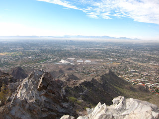
The first moment I knew things had changed was when I looked up and noticed the view of downtown Phoenix was marred by a tan wispy blanket of smog, noticeably thicker than my prior visits.

Then I started to also notice that extra paths had been worn in on the trail, where hikers take shortcuts around bends or to avoid traffic jams. The trail's edges seemed to be artificially wider than normal, showing heavy wear from its users.
Farther up, as the trail became steeper, my heart rate topped at 184 but my heart and head sunk when I glanced up from huffing and puffing to see the mark's of blatant human disrespect. Graffiti. With a sunken spirit I snapped the photo and continued on my way, probably 1/4 of the trail left to summit.

At the summit I was sad to see more graffiti, more bold statements of human conquer.


And, graffiti of an ornamental kind. I'm sure the intent was to be humorous and filled with good cheer; but this type of ornament, although making a pretty picture, is harmful to the animals and birds who should own this summit more than we do. The bow may very well break the bough and choke the sparrow.

I believe that we need more people to know our land and experience wildlife and nature. We need more people, most importantly our young people to connect with these things if we have any hope of proving its value and protecting its future.
But I wish more people would learn, teach, and embrace the principles of Leave No Trace.
But to me, Squaw is one of the first places that I encountered the feeling of accomplishment by meeting a challenge head-on and not giving up. I saw a huge lizard (chuckwalla I think), I braved wind storms and desert rains, I took on the world as a young strong single woman. So it's with fondness, appreciation, and a certain expectation that I went back to Squaw on a Monday morning in December.
I was greeted with a parking space directly in front of the summit trail, which is a rare occurrence. I plugged myself in to my heart rate monitor to hear my body's signals more clearly and I started up the trail that I had not conquered in at least a year.
The first moment I knew things had changed was when I looked up and noticed the view of downtown Phoenix was marred by a tan wispy blanket of smog, noticeably thicker than my prior visits.

Then I started to also notice that extra paths had been worn in on the trail, where hikers take shortcuts around bends or to avoid traffic jams. The trail's edges seemed to be artificially wider than normal, showing heavy wear from its users.
Farther up, as the trail became steeper, my heart rate topped at 184 but my heart and head sunk when I glanced up from huffing and puffing to see the mark's of blatant human disrespect. Graffiti. With a sunken spirit I snapped the photo and continued on my way, probably 1/4 of the trail left to summit.

At the summit I was sad to see more graffiti, more bold statements of human conquer.


And, graffiti of an ornamental kind. I'm sure the intent was to be humorous and filled with good cheer; but this type of ornament, although making a pretty picture, is harmful to the animals and birds who should own this summit more than we do. The bow may very well break the bough and choke the sparrow.

I believe that we need more people to know our land and experience wildlife and nature. We need more people, most importantly our young people to connect with these things if we have any hope of proving its value and protecting its future.
But I wish more people would learn, teach, and embrace the principles of Leave No Trace.
- Plan ahead and prepare
- Travel and camp on durable surfaces
- Dispose of waste properly
- Leave what you find
- Minimize campfire impacts
- Respect wildlife
- Be considerate of other visitors
Coming Soon: a real Tom's Thumb trailhead
Word has it that Tom's Thumb will be easier to access soon. This is one hike that I've always wanted to do but have not gotten past the unpaved roads Blue (my car) needs to travel on to get there.
The new trailhead will provide parking for 120 cars in addition to restrooms, ramadas, and horse access/amenities. The City of Scottsdale and McDowell Sonoran Conservancy will be the main players in making this come to life within the McDowell Sonoran Preserve.
Work on the Tom's Thumb Trailhead is expected to begin in 2011 and take 9 months to complete. So by this time next year we may be headed that way to check it out!
City of Scottsdale Project Overview
Article from The Arizona Republic
One hiker's account
Camelback: Rock Climbers & Killer Bees don't mix
Bees struck the climbing community again in November, but this time the climbers survived. According to a blog on the Phoenix New Times website, at least one beehive is located along the Hart Route, a popular Camelback climbing route touted in guide books.
These climbers survived the incident, unlike a climber who fell to his death six years ago trying to escape bees along this same route.
What I find interesting about this is that the independent blogger gathered and found more information than any of the local newshounds who left out the route name, and the history of other specific bee attacks.
Here are links to the stories:
azcentral.com
Phoenix New Times Blog
ABC15
Today's Hike: Sunrise Mountain Loop
The weather today was a brisk 58 degrees, cloudy with winds gusting up to 20mph. It rained in the East Valley but here in Peoria it was a nice day for a hike, so I headed over to Sunrise Mountain Loop to give myself the satisfaction of a 2 hour, full-loop excursion.
I wore my heartrate monitor for the first time on a hike just to get a sense of how my body operates and how difficult the hike really is. If you remember from my informational post about this hike, (Sunrise Mountain Loop) there are three loops making up the whole loop. You can choose to hike in any loop formation and I choose to go with the longest trek I could, and summitted all three hills, all successively taller than the last.
The first hill raised my heartrate to a quick 171, the second hill brought me above 160 for quite a stretch before topping out at 176, then the last hill tipped the high points at 178. My 2-hour hike ended up averaging a 137 heartrate and burned 961 calories.
Definitely a good way to end my Thanksgiving over-eating-athon.
Here are some photos from my trek today:


Trail Map from City of Peoria
I wore my heartrate monitor for the first time on a hike just to get a sense of how my body operates and how difficult the hike really is. If you remember from my informational post about this hike, (Sunrise Mountain Loop) there are three loops making up the whole loop. You can choose to hike in any loop formation and I choose to go with the longest trek I could, and summitted all three hills, all successively taller than the last.
The first hill raised my heartrate to a quick 171, the second hill brought me above 160 for quite a stretch before topping out at 176, then the last hill tipped the high points at 178. My 2-hour hike ended up averaging a 137 heartrate and burned 961 calories.
Definitely a good way to end my Thanksgiving over-eating-athon.
Here are some photos from my trek today:

 |
| Sad to see that the cairn I photographed in June is gone. See the cairn: June post |

Trail Map from City of Peoria
Flat Iron: One of the toughest hikes!
FLAT IRON via SIPHON DRAW TRAIL at LOST DUTCHMAN STATE PARK

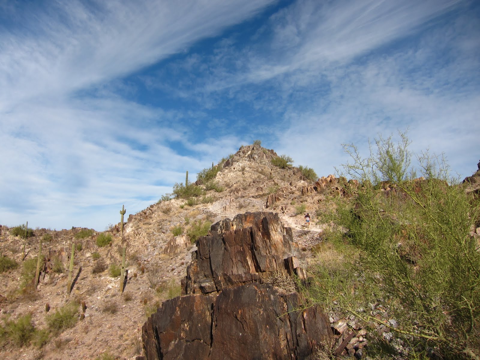
Flat Iron is part of the Superstition Mountains located in Apache Junction (east of Mesa). Lost Dutchman State Park is located on the west side of Superstition Mountain and is home to many popular hiking trails. One of the most difficult and interesting trails I have found in Arizona is the trail to Flat Iron.
 |
| X marks the spot on top of Flat Iron (your destination) |
One-Way Mileage: 2.8 to 3 miles
Elevation gain: ~2,800 feet (1,800 comes within the last mile)
Top Elevation: ~4,500
Experience Needed: Trail to basin (Siphon Draw) is accessible to most active hikers. Continuing on to Flat Iron is recommended for experienced hikers only
Difficulty: Trail to basin- Moderate. Continuing to Flat Iron - Strenuous.
Parking: Plenty of parking at Lost Dutchman State Park ($7 entry fee per vehicle)
People Meter: Siphon Draw is a highly traveled trail. Most people turn around after the basin, so the first 2 miles are where you will see most other people. It was Thanksgiving when we first went and we saw quite a few coming back down the trail as we started at 11am. We encountered a few people hiking on their own, but most were traveling in groups as families out for a holiday stroll. At the top, I remember just one man and his son enjoying the views and a quick rest before continuing on.
 Safety: The first two miles of the hike are the easiest but still create a breathless heart-pumping jaunt. The trail winds through the desert and into the Siphon Draw canyon. Once you hit the slickrock basin (see the right), it's time for the average hiker to turn around. But the more daring and experienced hiker will forge ahead to reach the iron in the background. From the basin the trail gets steeper by the second. The rocks become larger and two hands are necessary to help guide yourself up through the narrowing canyon walls.
Make sure you carry enough water for the heart-pumping endeavour you have begun. We first hiked this on Thanksgiving Day of 2009. We began our hike about 11am and finished right at sunset -- around 5:30pm. The day was cool and we carried enough water and snacks, but I did not drink my water at regular enough intervals. By the time we surpassed the last 15-foot rock and hit the top, my calf muscles were cramping just to remind me who was boss. At the top of the Flat Iron you reach one of the most healthy looking desert landscapes on a relatively flat stretch of ground that you'll be happy to see after climbing up, hand over foot, that last 1,000 feet of craggy puzzle work. Once we reached the top I set out in a half-jog, half-skip and pretty quickly ended up doubling over with a Charlie Horse I was not expecting. So, please, I urge you, drink your water every 1/4 mile!
My experiences: This hike is one of my favorites in the Valley. It's close to home but offers outstanding views, a completely unique landscape that transports you into an alter universe, it was like exploring the moon. It is a puzzle the entire way, new landscapes, new rock formations, it engages your mind just as much as your body.


http://www.azstateparks.com/parks/LODU/index.html#fees
http://www.azstateparks.com/parks/LODU/downloads/LODU_Park_Map.pdf
http://hikingarizona.blogspot.com/2008/02/hike-28-siphon-draw-trail-superstition.html
http://hikearizona.com/decoder.php?ZTN=686


Links to other information about this hike:
http://www.arizonahiking.org/flat_iron.htmhttp://www.azstateparks.com/parks/LODU/index.html#fees
http://www.azstateparks.com/parks/LODU/downloads/LODU_Park_Map.pdf
http://hikingarizona.blogspot.com/2008/02/hike-28-siphon-draw-trail-superstition.html
http://hikearizona.com/decoder.php?ZTN=686
Humphrey's Peak; the highest point in Arizona
HUMPHREYS TRAIL
Humphreys Peak is part of the San Francisco Peaks located in Flagstaff and offering unparalleled views of the state of Arizona.
One-Way Mileage: 4.5 miles (according to the Forest Service, but we think it's more like 5 miles total mileage)
Elevation gain: ~3,000 feet
Top Elevation: 12,637 (according to Wikipedia)
Experience Needed: Recommended for experienced hikers only
Difficulty: Strenuous
Parking: Uses the parking lot for Snowbowl Ski Resort in Flagstaff.
Pets: Saw some on our hikes but I wouldn't recommend taking them all the way to the top.
Safety: This is a long, steep, rocky trail. Wind can gust at extreme speeds. The trail above the treeline is like walking through a field of loose shale and lava rock and is very exposed. Use caution! The trail is also subject to human traffic jams, so be courteous to other hikers and keep an eye on the trail. Due to the elevation of this hike, some may experience altitude sickness. Stay tuned to your body and resist summit fever. Be wary of stormy weather, especially during monsoon season when lightning is a risk factor.
People Meter: Highly traveled trail. The summit had at least 10 others already up so don't expect to get the tippy top to yourself.
My experiences: June 9th 2009 (the day after Richard's 35th birthday) we attempted Humphreys Peak. Richard had hiked it before but it was my first time and we were on our way home from a fishing trip to Lee's Ferry. We stopped over in Flagstaff and checked the weather hoping we could take the day to summit the highest peak in the state. The weather forecast was a little sketchy but we thought we'd give it a go anyway. Getting to the trailhead around 9 we started the hike. Over Memorial Day I had tweaked my knee walking the steep streets of San Francisco and my left hand was in a plaster cast from pulling a tendon in one of my knuckles so I only had one hiking stick. These things should have been good indicators the hike was not going to go off as planned. We made it to the saddle that day but it was BITING cold and horribly windy. We agreed to turn around there since I wasn't in the best shape and we started to see snow flurries as we ate our power snacks.


We tried the hike again on August 30th 2009 (the day before my 32nd birthday). This time we were successful. There were tons of people on the trail, including dogs, cell phone talkers, and people of various ages and physical conditions. It was a long hike and I tied my shoes too tight. By the time we got to the parking lot my feet were swollen and throbbing! But the feeling of being on the top of Arizona was worth it. I felt no ill effects from the elevation gain but I did feel a little euphoric... is that a side effect?
The snow was gone from the saddle

The trail above 12,000 was loose rock


Yippee I made it!


Links to more information:
Sunrise Mtn Loop: A good warm-up experience

May 16, 2010
The week before we left for our rim to rim Grand Canyon trip I took Richard hiking at my newfound Peoria trail, the Sunrise Mountain Loop. I figured it was a good warm-up since it's only 15 minutes away and in total it gains 1500 feet (over the 3 humps) and it's not the standard all up and then all down hike. You go up and down 500 feet at a time so I figured it might be a better training mechanism for the Grand Canyon since there you go down before going up and your body has to have energy left once you get to the bottom otherwise you're not getting out again.
Usually in the Phoenix area it's already hit over 100 degrees by this time in May but this year summer took a side-trip so we were lucky to still see some blooming flowers. Richard was trying out my new camera so photos shown here are his works of art.

The Heat is On: Sunrise Mountain Loop
There is an inverse correlation between the heat and the number of people you see on the trails during midday. I typically like to hike in late morning or afternoon. Last weekend I was out at 3pm. It was about 95 degrees I think. I saw two male hikers exiting as I arrived, one mountain biker, one female hiker/jogger, and one other male hiker. No pets, thank goodness, although I did scout lots of lizards out for a tanning session as I rounded the third bump.
Today was 100 degrees and I was out from 12-2pm. I passed a two female hikers leaving the trails as I headed in, two teenage boys jousting with wooden swords on the top of the second hump, and one male jogger. It takes me 2 hours to complete the loop and these past two weekends have been pretty brutal, I stopped twice today in the only shade I could find for a quick relief from the hot hot sun. But I love hiking during the summer.
For one, you get the trails to yourself for the majority of the hike. Plus, I have really bad allergies and the spring although completely gorgeous reaks havoc on my head, causing me to sneeze til I can't breathe and want to rub my eyeballs until they pop right out of the socket. The heat also has alot of mental benefits I think. I feel like the hike is a bigger challenge and puts me even more in tune to what's going on inside my body and it helps me sweat all the toxins out and I feel refreshed after a long hot hike. Probably alot like Bikram Yoga, although I haven't tried that yet.
Anyway, last week when I headed up the last hump to get to my "summit" I saw there's a new cairn that stands 6 feet tall or so at the very end of the trail. It was put up sometime between early May and June 10th and adds a bit more interest to your photos.

ID this bug -- Sunrise Mountain Loop
Hiking the Sunrise Mountain Loop yesterday I nearly stepped on some crazy red-headed bugs crawling out of the ground. There were about six of them slightly spread out among one small patch of trail but the red of their bodies was starkly in contrast to the rest of the trail. I tried to get some shots in order to try to identify them later but my google search has come up empty so far.


Thunderbird Park: 67th Ave & Patrick Lane
The City of Glendale website lists all the trails available at Thunderbird Park. At the 67th Avenue and Patrick lane entrance you are greeted by a small trailhead but have access into the Western end of the park. All of the trails are rated easy to moderate, so it's great for a leisurely hike, have a picnic, get back into the swing of hiking after an injury, or for a quick outdoor fix on your way between the East and West sides of Phoenix.

Experience Needed: Nothing special. Get out and walk!
Difficulty: Easy to Moderate.
Parking: At the stoplight of 67th Ave and Patrick Lane, a dirt trailhead parking lot sits to the east. On a busy Saturday late afternoon in March (the best time of year in AZ) there was no trouble parking even though the lot is fairly small.


 For more info and photos from the H-3 loop that's easy to access from the 59th Ave entrance, check out that post here: Thunderbird Park: 59th Ave, North of Deer Valley Road
Check out the City's website for maps, trail information and other details. http://www.glendaleaz.com/PARKSANDRECREATION/parksandfacilities/thunderbirdpark.cfm

Photos & art by Amy Bartlow
Mileage: Each trail intersects with each other, so it's likely your hike will cover sections of more than one trail. For context looking at the map above, trail H-1 is 5 miles in entirety, while H-3 is 3 miles. However, if you take H-3 you'll end up hiking a portion of H-1 to make it a loop so you're nearing 5 miles with that custom loop.
Elevation Gain: If you're looking for elevation gain check out the topo map on the City's website. It appears that the bottom elevation at all the trailheads is around 1350'. The top of H-4 which is the nearest hump to the 67th entrance takes you up to about 1650' so about 300' over a short distance. Over to the north on trail H-3a you can reach 1800'. And the top of trail H-2 appears to hit 1850'.
Experience Needed: Nothing special. Get out and walk!
Difficulty: Easy to Moderate.
Parking: At the stoplight of 67th Ave and Patrick Lane, a dirt trailhead parking lot sits to the east. On a busy Saturday late afternoon in March (the best time of year in AZ) there was no trouble parking even though the lot is fairly small.

Pets: Dogs, cats, and this park is also open to trail stock (aka horses)
Hours: Sunrise to Sunset. Gates will lock you out at sunset.
Safety: Watch for mountain bikers and dogs. I've heard of some car vandalism/theft so lock your valuables up and out of sight. Take your cell phone with you on the hike. Remember as always to carry enough water, and bring a headlamp just in case you get stuck. It's not hard to find your way, visibilty is great, and these are well traveled trails so be courteous to other hikers.

People Meter: Lots of people, young and old, with canes, bikes, dogs, and babies.
My Experiences:


EastWing Mountain Trail
EAST WING MOUNTAIN TRAILS
 The City of Peoria, AZ website indicates there is a Beginner trail and two varying levels of Intermediate trails at East Mountain. The Beginner trail takes you up a short hill to a bench where you have a nice view of the Park where you most likely parked your vehicle. The Intermediate trails take you back behind the neighborhood for a very nice jaunt through the desert hills. For more information on all the hikes check out the City's website at: http://www.peoriaaz.gov/content2.aspx?ID=967
Mileage: Beginner -- 0.4 miles loop, Intermediate -- 1.8 mile loop.


 The City of Peoria, AZ website indicates there is a Beginner trail and two varying levels of Intermediate trails at East Mountain. The Beginner trail takes you up a short hill to a bench where you have a nice view of the Park where you most likely parked your vehicle. The Intermediate trails take you back behind the neighborhood for a very nice jaunt through the desert hills. For more information on all the hikes check out the City's website at: http://www.peoriaaz.gov/content2.aspx?ID=967
 Mileage: Beginner -- 0.4 miles loop, Intermediate -- 1.8 mile loop.
Elevation gain: Beginner: 71' gain. Intermediate: 457' gain.
Experience Needed: These hikes are good starter hikes. Excellent for folks who live in the area and are looking for a new places to explore without the perils of being too far from home.
Difficulty: Easy to Easy-Moderate.
Parking: The trail head for East Wing Mountain is at Sonoran Mountain Ranch Park at 7098 W. Miner Trail, Peoria, AZ 85383, which is basically far north on 67th Ave. The park has picnic tables, a playground and restrooms.
View of Parking Lot at Sonoran Mtn Ranch Park from top of Beginner Trail (below)

View from top of Intermediate Trail (below)

Pets: I did not see any animals on my hike but the website says they are allowed as long as they are on a 6 foot or less leash, and you are vigilent about picking up the puppy poo.
Hours: Sunrise to Sunset
Safety: For my first adventure into this trail system in February 2010, safety seemed pretty standard. No major concerns, I could see the parking lot where my car was parked for most of the hike and it's very close to a new housing development. So take the standard precautions -- headlamp, water, cell phone, sunscreen, good shoes, etc.
People Meter: The trail seems fairly new so it may not have high awareness yet I ran in two young teenagers only on my hike.
My experiences: All photos via mobile in February 2010 on a rainy Sunday afternoon. I thoroughly enjoyed this hike because really as soon as you get up to the top a whole world expands with 360 degree views, if you squint hard you can even see downtown Phoenix. It was a fairly leisurely hike, great if you don't have much time or just need to get some air. The back side of the mountain shown below is all undeveloped land. I believe the city may be creating more trails on that side of the hills. Makes you realize how lucky we are to still have patches of wilderness in the middle of the city that we can get away and explore.
Photos:
The rain drew out all the greens on the desert floor. This photo (below) was taken from early in the hike. The Intermediate trail goes up to the point in the center.

The first part of the trail is a nice wide social trail, easy for hikers to pass on either side. (below)

View of the Intermediate Trail on way back down the loop to the parking lot. Here you can see the trail narrows and is a bit rockier than on the earlier sections of trail (below)

Subscribe to:
Posts (Atom)