
Vulture Peak is located near Wickenburg, Arizona. We used the write-up from azcentral.com and from arizonahiking.org to help us on our first trip up the mountain. Both sources said that this was a strenuous hike with some scrambling at the top. As a not-so-experienced scrambler (just Camelback and Flat Iron in my history really) I wanted to make sure I knew what I was getting into before we went so I also asked our facebook followers if they had any words of advice to which I learned it’s an “easy trail to the saddle, a bit of loose scrambling, maybe a touch of class 3 and some loose rock near the summit.” Armed with this information I felt that I could manage to at least go check out the hike. So one late October Saturday we headed west on the US-60 (Grand Ave).
Mileage: Our GPS device says we traveled 4.35 miles roundtrip over 3 hours time (we stopped at the top for quite some time since there were goodies there we found interesting.)
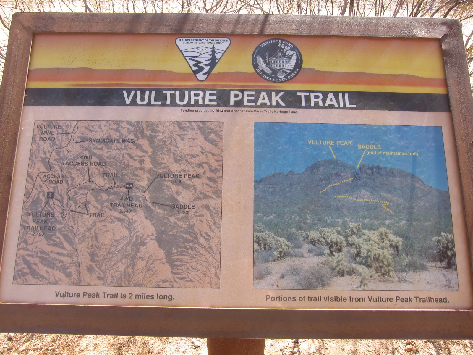
Elevation Gain: GPS says we started at 2,424 feet and went up 1,589 feet (this counts all the ups and downs).
Top Elevation: GPS says we maxed out at 3,635 feet. So we really gained roughly 1,200 feet from bottom elevation to top. According to the BLM the saddle is roughly 3400’ so the last scramble is about 250’. The graph below plots the elevation (green) and our speed (blue) as we traveled.

Experience Needed: The trail is steep, reaching the saddle in about 2 miles. Most sources say the scramble should be attempted only by experienced and well-conditioned hikers. After reading the notebook found in the army cache box at the summit I would say that many of those who have successfully attempted the summit are not necessarily experienced and many of us have some sense of “Holy Shit” as the attempt is made. But if you are careful, confident, and conditioned you should be okay. The last scramble for me was a slow go as at a 5’4” stature some hand and foot holds always seemed to be out of grasp and I worried that I may not be able to figure out the way down again. On the way down, (mostly crab crawling) I realized that it wasn’t quite as treacherous as I feared it would be but still made sure to go slowly since a 200’ feet fall is a long one.
Difficulty: Moderately strenuous; strenuous above the saddle, once the scrambling comes into play.
 Parking: Free and most likely not an issue. There is dirt trailhead parking (for 15 vehicles) and even closer four wheel drive parking (for four), but the hike to the upper parking lot was not that big of a deal, as it allows you to familiarize yourself with Vulture Mountain and its terrain before you get into the real ascent. There are trailhead restrooms but no water stations.
Pets: We encountered no one hiking Vulture Peak while we were there, only two men leaving the trailhead as we arrived, so we witnessed no pets. However, I have seen photos of dogs on the peak. These dogs must be related to mountain goats to easily get themselves up and back down the scramble. And the signs indicate that horses may use these trails as well.
People Meter: Very low. This was a great secluded hike that had parking and trailhead restroom facilities.
Safety: AT&T cell service was limited but Verizon worked. The trail and trailhead are maintained. The hike is near the city of Wickenburg but it's out of shouting range to houses. The trail is steep. Safety issues may mostly surround injuries, animal encounters, and navigation during the scramble to the top (in case you find yourself stuck somewhere). I suggest you always take a hiking partner with you and you make sure you have enough water as the strenuous nature of the hike will likely leave you thirsty and there is no water at the trailhead.
Other Links:
http://www.summitpost.org/vulture-peak/153094
http://www.wickenburg-az.com/2002/01/vulture-peak/
http://www.blm.gov/az/st/en/prog/recreation/hiking/vulture.html
My Experience: This was a great hike that is now on my "Most Do Once a Year" list. As you’ll see in the videos the last scramble up (if you choose to go to the summit) was slow-going for me as I was carefully planning and testing my moves to make sure I didn’t topple over and fall down the hill. I had some anxiety related to thinking I’d get stuck or would take too large of step up and not be able to get back down without going for a parachute ride without a parachute. On the way down it seemed less sketchy than I imagined it would be on the way up. Once at the top there we found three geologic markers from 1948 and an army cache with notebooks and water bottles. The notebook was a fun diversion and good excuse to lounge on top for awhile. We read in the notebook that someone got married up there not long before. It was a great summit too because we had the peak to ourselves, vs. the Phoenix city hikes that leave you waiting for a parting of the seas to get a good photograph of the view.


