"How to Clean Water Bottles" by Richard Anderson

We just got back from a 5-night backpacking trip to Yosemite and we have gear to clean. My husband, Richard, is one of the best gear maintainers I've ever met and so, as I shared his instructions for how to clean backpacks, now it's time to clean water bottles. 

This might seem really simple to you, but honestly I wasn't sure how to do this without his instructional guidelines.  These bottles had been with us through dirt and grime and slobber, possibly hantavirus exposure, but yet we want to get the most out of them since they are not "disposable" water bottles. I wanted to get them clean enough to use again, yet not so clean that I felt like I was drinking cleaning solution and not so grimy I felt I was still tasting Yosemite on our next trip.

So here's the run-down.

What you need to do this:
  • Dirty water bottles (shown: 1 Party Platypus, 1 Platypus water tank, and 2 Nalgene Canteens)
  • A scrubby brush (shown: Platypus scrubber brush)
  • Dish soap (shown: Dawn Direct Foam)
  • Bleach (Clorox Bleach)
  • A sink and drainstopper (kitchen)
I made a video of this process but since no one else was home I tried to tape it and act it out one-handed and, although I may be very talented, it was a pretty poor video. Instead, for your listening pleasure you can listen to the instructions and the sound effects of what it's like to clean your water bottles. 

At the end I mention we're going to let it sit for 10-15 minutes. My husband actually instructed me to let it sit for 5-10 minutes before using the scrubby brush. And actually in the end I forgot about them in the sink and left them sit for more like an hour before remembering to go back and scrub them down.  Now they are pretty clean and drying on the rack.

Here's the step run-down one more time:
  1. Collect your supplies
  2. Insert drain stopper in sink
  3. Start filling sink with hot water
  4. Squirt liberal amounts of dish soap in the water
  5. Pour in 1/2 a cap full of bleach, no more than that (refer to picture to know how large a cap I'm talking about -- not very big, less than 1 inch) -- I think I put in 1 cap of bleach, so hopefully I haven't degraded the plastic or the drinking pleasure. I think I'm okay though, there was a large water to bleach ratio.
  6. Take caps off water bottles
  7. Throw water bottles and caps into soapy water being sure to get submerged in the water
  8. Walk away for 10 minutes
  9. Come back, fish out the lids, rinse them off and dry them
  10. Unstop the sink to allow for draining while running clean water
  11. Use the scrubby brush on the inside and out, in the nooks and crannies while rinsing
  12. Dry on rack
  13. Pack up, get dirty and do it again.

This process can also be used to clean water bladders that are inserted into your backpack. There is a longer skinnier scrubby brush you can use to clean the drinking tube. 


Grand Canyon S. Kaibab - Bright Angel Loop May 2012


On Saturday May 19, 2012 Richard and I descended from the South Rim via the 7 mile South Kaibab Trail. Our intent was to hike the 2nd most popular trail to see how much more difficult it is than Bright Angel Trail and to determine if it would be a worthy shortcut for future longer trips. It was intended to be a short trip – just two nights down at Bright Angel Campground to give one rest day before heading back up the 9.6 mile Bright Angel Trail.

Once again the waterproof Nomad hiking journal was packed deep in a pocket with a rolling ball pen (big mistake) to smudge every word of our trek.
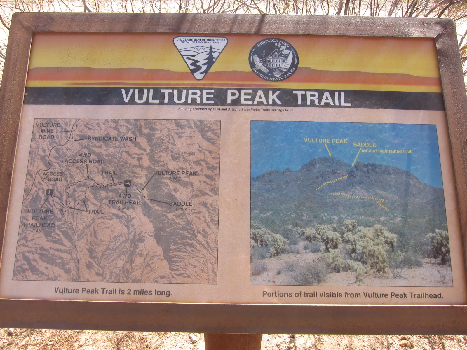
Sat 5/19, DAY 1:
Starting Point: Grand Canyon Lodge parking area 2. Take Orange Shuttle Route to S. Kaibab Trailhead.
Trail link: http://www.nps.gov/grca/planyourvisit/upload/South_Kaibab_Trail.pdf
http://www.nps.gov/grca/planyourvisit/upload/SouthKaibabTrail.pdf
Destination: Bright Angel Campground @ Phantom Ranch
Miles Covered: 7 miles
Elevation Loss: 4780’ elevation loss (this is 400’ more than using Bright Angel Trail)
Hiking Time: 3 hours and 54 minutes (Left at 9:38 am and arrived at 1:30 pm)
Pack Weight: 25-30 lbs.  (we calculated that we were probably around 18% of our body weights)
Temperature: 60-90°
Sky: All sun
Precipitation: nothing of any kind unless you consider mule spit precipitation.
Wind: the perfect breeze
Difficulty: 4 out of 5
Calories/Heart Rates: Burned 1520 calories, Max heart rate of 157, average of 124.
Water Availability: None on the trail. Pack more than you think you need. We had 1 gallon each.

Trail Conditions: South Kaibab is one of the most popular trails in the canyon, so expect your shuttle bus to the trailhead to be crowded. The shuttle is free but with that comes demand. Lucky for us there were few other backpackers on the bus so our bags fit nicely in the front storage area. Once you get to the trailhead, the thirty of you will all clamber for the same scenic views and rush down the trail. We took our time to take our first photos, read the information, and soak it in before embarking. The information signs remind you not to be overconfident and misinformed – a young woman who had run the Boston Marathon in under 4 hours died at the Canyon trying to complete the 27 mile rim-to-rim with only 1.5 liters of water, 2 energy bars and an apple. Don’t be her! Take your water, know your route, eat often.

As the trail is popular, you’ll encounter many people within the first few miles of the hike. Less than a mile down the trail you’ll arrive at your first tourist destination -- Ooh Ah Point -- but I held on to my Oohs and Ahs for areas less crowded. Crowds are mostly human but there are also mule trains. For a couple years mule service was inactive on this trail while trail improvements were made but the mules were back in service last year, so be aware that mules have the right of way and you should step to the inside of the trail and let them pass. This might be difficult at times because the trail is definitely narrower than Bright Angel and you are forced into single file quite a bit – which makes it a snug fit for the mule trains to pass by along narrow switchbacks. If you see them coming you should scope out a good broad area to step aside.

As this trail is nearly 3 miles shorter than Bright Angel and starts at a point 400 feet above BA, it is most definitely steeper and does wear on your knees. The brunt of the wear in our opinion comes after Tipoff when you have only 2.6 miles left to go and need to orient yourself to make sure you take the right trail heading out of Tipoff and do not end up on Tonto East which leads both East and West from Tipoff. Once you’re on the right trail, the descent to the river is toe-smooshing and knee-jarring. Hiking sticks are incredibly beneficial to distributing your weight and stabilizing yourself along the exposed trail.

Notes: Although there is no water along the trail there are a couple points with pit toilets – Cedar Ridge is your first stop and Tipoff the second. Below Cedar Ridge, there are no shady rest spots that compare to the oasis of Bright Angel’s Indian Gardens.

With little shade, the views of South Kaibab are incessantly in front of you and you may catch the flight of a California condor, one of the rarest bird species and one that is rebounding from massive conservation efforts. The informational packets about the trail say you will see less wildlife on this trail than Bright Angel due to its track across a sun-exposed ridgeline. We saw the condors, spiny lizards, and several squirrels. Perhaps the “wildlife” they speak of it means “deer” which you pretty much are guaranteed to see at least one of on your way up to Indian Garden, but none on S. Kaibab.

Zoroaster’s Temple, the butte that watched over us on our hike to Clear Creek last year, peered down on us again this entire hike. Zoroaster was named after a Persian prophet of probably one of the largest religions before 6th century BCE. Zoroastrianism used water and fire as elements of purity in ritualistic ceremonies as they are thought to be necessities to life. Wikipedia says: “Fire is considered a medium through which spiritual insight and wisdom is gained, and water is considered the source of that wisdom.” So be wise and carry water, if not for yourself, than for the Zoroaster who reigns above you in the Canyon.

Carrying a gallon of water each, we arrived at camp with extra water, but neither of us wishes we took less. We saw so many people poorly dressed and poorly stocked for the rigor of this trail we wonder how often rangers must help hikers overcome their self-induced obstacles. We also count our lucky stars we made it down, safe and sound, with just the aches of a knee and foot pound.

We camped at spot #4 in Bright Angel Campground, next door to our favorite camp from last year, set up our tent (we carried no fly since the forecast was hot and sunny), and inventoried our maladies. Richard’s brand new Saloman’s XA Pro 3D Mid 2 GTX shoes did the trick straight out of the box, no blisters, but he did indicate toenail soreness and hotspots which he attributes to the trail’s grade, not from his shoes. I also found no blisters from my Saucony low top trail runners but did have a left knee ache and a sore shoulder from the less than plump straps of my Osprey Aura 65.

One of the most pleasurable things about camp #4 (or #3 or any of those on the east side of the campground) is Bright Angel Creek’s cold water lapping over your sore body parts. This is my Ooh Ah point!

Camp was set up by 2:30 and we were looking for nourishment in the form of hops and barley so we wandered into Phantom Ranch to the cantina where we were surprised by a rich 3 can selection: Budweiser, Tecate, or Grand Canyon Wheat. We got one of each and then I settled on Tecate and Richard on GC Wheat for our standby favorites. ($4.75 for Bud and Tecate, $5.75 for GC Wheat)

By 4:30 Richard had picked up his fly rod and was fishing along the confluence of the Bright Angel and Colorado rivers. Within the first 10 minutes he caught a 14 inch brown trout. Later we learned from the ranger that they were shocking the water that night to pump the stomach contents of the brown trout and analyze its diet. No word on what they were looking for, or what they found.

Over dinner we wrote down the items we forgot or screwed up in our prep: no hairbrush, somehow instead of 2 foam cups we had 1 foam and 1 plastic, brought an extra bottle biodegradable soap, shouldn’t have bought the Backpacker Pantry meals with olive oil packets as it’s just too messy and oily. Richard needs flip flops but decided his water shoes with wool socks worked out well for him.

At 7:30 we joined Ranger Emily at the small amphitheater for her talk on the Kolb Brothers. We learned about their adventures, their photography business, and other random information about the Canyon – like the pictographs along Bright Angel Trail that we had never seen and the planned eclipse viewing parties for Sunday night between 6:30 and 6:40– Plateau Point near Indian Gardens would have a view as would a point 2 miles up S. Kaibab Trail.

Sun 5/20, DAY 2:
Starting Point: Bright Angel Campground #4
Trail: N. Kaibab Trail out of Phantom Ranch, after crossing the 2nd bridge about 2 miles down the trail we crossed Bright Angel Creek and entered the Canyon.
Destination: Phantom Creek/Canyon
Miles Covered: maybe 4 miles round trip to the canyon entrance and back to camp.
Elevation Gain: 400’ elevation gain maybe
Hiking Time: 30 minutes to reach the canyon, 15 minutes or less to reach the 1st waterfall where we hung out (Left at 8:30 am and came back to camp before 2 pm)
Pack Weight: 5-10 lbs.
Temperature: 95-100°

Sky: Sunny
Precipitation: nothing but sun
Wind: slight
Difficulty: 1 out of 5
Water Availability: lots of water on the water hike, bring water filter.

Trail Conditions: Following N. Kaibab Trail to the Canyon is a good trail, fairly flat, but wide enough to handle traffic. Plenty of shade through the canyon in the mid-morning. After crossing the 2nd bridge the canyon will come up on the left, it’s the first new water source (Phantom Creek) creating a confluence with the Bright Angel Creek. You must get off the trail and cross the Bright Angel Creek to enter the canyon. Hiking sticks are a great way to guide your tired and sore legs through the current but the current was gentle. I found a spot deep enough to soak my knee, now wrapped in athletic wrap, and the coolness of the creek immediately felt anti-inflammatory. In Phantom Creek the water was slightly warmer than Bright Angel Creek and was a gentle flow, not too hard to navigate through. There are a few places you need to really think about how you’ll step to get over mini-cascades but nothing was too terribly difficult. At the first waterfall we chose not to climb up the rock fall to the left to get to the upper falls because I was nursing my knee in preparation for the hike out and didn’t want to be stupid and hurt it more at the wrong time.

Notes: There is fish in Phantom Creek. Richard didn’t anticipate this so he didn’t bring his fly rod with him, but once we got in Phantom Creek he saw two dead suckerfish and then saw trout swimming in the pool below the waterfall. He was jonesed to fish so I rested along the confluence for an hour while he hiked back to camp, got his rod and came back. During that time I watched the sun gradually throw light across new parts of the canyon walls, rested my knee, waved at canyon hikers passing by, investigated different rock types along the creek, and just enjoyed the peace. A couple other hikers went in the canyon while Richard was gone and as we hiked back to the waterfall at 11:30 we saw them up above the 3rd waterfall. Richard fished and quickly caught a rainbow trout with an elkhair #14 while I watched two lizards scurry up and down the rocks to eat tadpoles or larvae out of the pool’s edge.

On our way back to camp we stopped at the cantina to beer up and get a $3 bag of ice for cold water and knee therapy and then it was back to camp for my rest day and Richard’s fish day. He went down the creek for another few hours but only caught 1 more brown trout (with a tarantula pattern). I watched people soak in the creek while the sunlight sparkled through the cottonwood trees and the sun warmed the rocks to frying pan temps. When Richard came back at 4:30 there was a weird hot breeze circling through camp. The eclipse was at 6:34 but we didn’t notice much change in the sky. I thought the sky was hazy and then brightened after the ring of fire ended but Richard didn’t corroborate that story. To bed at 7:30 with plans to wake at 5 for the hike out. My knee felt better after taking Aleve and it wasn’t until we got home that I realized I was only supposed to take 1 every 8 hours and I was taking 2 every 6 hours. No wonder I thought it worked better than Advil!

Mon 5/21, DAY 3:
Starting Point: Bright Angel Campground #4
Trail Link: http://www.nps.gov/grca/planyourvisit/upload/Bright_Angel_Trail.pdf
Destination: South Rim via Bright Angel Trail
Miles Covered: 9.5 miles
Elevation Gain: 4380’
Hiking Time: 5 hours 55 minutes (Left at 6:20 am and arrived at 12:15 pm)
Pack Weight: 25 pounds
Temperature: high 106°at Phantom Ranch, 95°at Indian Gardens
Sky: Sun
Precipitation: none
Wind: slight
Difficulty: 3 out of 5
Calories/Heart Rates: Burned 3087 calories (1000 by Indian Gardens), Max heart rate 182, average 145.
Water Availability: great

Trail Conditions: Hot! Limited shade. Between the River Resthouse and Indian Gardens we crossed 4 water crossings. For some reason, I always remembered this in the past as 2 water crossings. Arrived at Indian Gardens at 9 am. It felt like there were fewer people hiking but I believe that might be because it was a Monday. At the top the usual place we’d enter/exit the trail would be by the Kolb Lookout Studio but they have closed that entrance and route you over to the West. It’s a longer path up but might also save some traffic jams that inevitably happened at the former trail exit. We don’t know if the prior path is closed permanently or temporarily.

Notes: We ate our breakfast of oatmeal with dried fruit out of plastic bags (because Richard wouldn’t let me pack the extra weight of a collapsible bowl) and it spilled all over my lap in the morning. I suppose these are the risks you take when you cut weight. I also ended up carrying a blue Sharpie with me the whole way in my REI Flash bag, which was a surprise to me when I was unloading my stuff later on. Anyway, the hike up was long and hard as usual. We saw a deer before arriving at Indian Gardens. We learned that taking an empty 20 oz bottle is a good way to get extra water at the water stops without having to go through the hassle of filling up the bladder in the backpack. Only one mule train passed by us on our hike.

Richard kept looking for the pictographs the ranger told us about but kept coming up empty until serendipitously I randomly made a rare stop below 1 ½ mile to take a rest and Richard “found the motherlode!” He was so excited and pointed them out to some foreign tourists who did not seem so impressed. I can’t believe we had never seen them before and if we had not made that rare stop we would have passed by them again unknowingly.

Once on top, we filled our bellies with more beer, margaritas, and fried mushrooms, zucchini, and French fries and then headed to Mather Campground and the showers! Keep in mind the showers are closed from12-1 and 3-4 for cleaning. We had timed it magically so that we would be the first to use clean showers. What a nice surprise! The shower area takes $2.00 in quarters for 8 minutes of hot water. They do not have a change machine but the attendant will make change for you.


For another Grand Canyon hike check out our 5 nighter to Clear Creek from 2011


Camelback: Don’t forget your water.

Today, as part of my pre-Grand Canyon training routine, I headed over to Camelback to test out my shoes, train my legs, and confirm if my new Kuhl shirt really does lower my skin’s surface temperature by 7 degrees. None of this testing was scientific but it was all on my mind. As it was midweek and midday, the trailhead parking was not the usual pain. You can even see some empy spots in the lot.  


My last hike on Camelback was almost exactly a year ago during last year’s pre-Grand Canyon training and today’s trip reconfirmed two ways this trail is more difficult than Piestewa.


1) The trail has more large steps and boulder hopping which not only works your quads and your balance, but also forces you to scramble at times. Some were wearing gloves to help reduce the scratches and wear on their hands. Plus gloves probably help protect hands from the scorching hot metal handrails at the beginning of the trail.


2) The trail is not quite as easy to follow. I think some trail maintenance has been done since last year and a few new “Area Closed” signs seemed to be up along the routes. This can lead you to worry you have veered off the trail when you haven’t. At one point I stopped for a breather in the little shade I found, drank some water and ate my lunch (I was out at lunchtime). I took a photo of downtown Phoenix and some lizards deep in discussion. While I sat there, a bunch of people in separate groups came around the corner and all seemed to look around a bit before figuring out where the trail went.


When I got to the peak, strangely no one else was there. Less than 1/8 of a mile from the top, on my way down, a couple of fellows from Florida asked me where to go to get to the top as they seemed to be a bit lost and my pink shirt was like a beacon on sea. The way down I find the route finding to be a bit more puzzling than the way up, but I was able to figure everything out since I've been hiking there dozens of times now. However, at Squaw (Piestewa, sorry) it is very easy to find the way to the top and a newbie shouldn't have any trouble with it.


Another puzzling factor to me was that out of the dozens of people hiking, I can fairly confidently say that half of them were not carrying ANY water. It was noon, it was 93 degrees, the humidity was up in preparation of a pending rain cloud, and the shade is minimal. Many of these sans water hikers were also shirtless or wearing very little which means they probably needed water way more than I did to cool their body’s internal heating system.


This is one  of about a million different ways that we are different than the many lizards that inhabit the mountain. They don’t need as much water because they are ectothermic to our endothermic. They are able to control the blood flow to their skin, darkening or lightening their color based on keeping their body temps at a consistent level (if they are dark they’re trying to warm up, if they’re light they’re trying to cool down). I don’t have the luxury of changing my skin’s blood flow so I take other precautions to lower my body temps to help withstand the physical strain of hiking in the desert. Light layers of clothing, a hat, and ample water are three ways that I do this. I might look weird in my get-up but I just don’t understand why anyone would want to hike at noon in Arizona with NO water.


I’ll have to go back in August and see if this phenomenon still holds true when temps are above 110.


Other posts about Camelback:
http://www.outsideaz.com/2010/03/camelback-echo-canyon.html
http://www.outsideaz.com/search/label/camelback%20mountain

And about Piestewa (Squaw) Peak:
http://www.outsideaz.com/search/label/piestewa%20peak%20hiking

Piestewa Peak with Grand Canyon on the Mind

It’s training time for the Grand Canyon again which means I’m out to conquer Piestewa and Camelback multiple times before we leave. The last time I hiked Squaw was the day after Christmas and it was a-bustle of activity. Today I arrived around 11:30 and found the main parking lot about half full. 93° and midday midweek probably has some influence on this. Hikers were sparse, shade even sparser. At my first rest at the 2nd to last bench I had to eat some lunch to keep my energy up. I met a lovely fellow the age of 62 who was out hiking with heavy Nikon camera equipment in order to acclimate before he hikes to Phantom Ranch with half a dozen others next week. He was a nice Chicagoan man and we talked camera talk for awhile. We spotted a hawk but by the time he had his camera ready, the hawk had disappeared. I have to say looking at the weight and bulk of the fancy camera I am quite happy with my small and sleek Canon S95. It takes quality photos and is the perfect size for backpacking.


Up at the first handrail I noticed they’ve been working on the trail – at least enough to put in a “Stay Out” sign to try to keep hikers from making shortcuts around the handrail area. I think last November this was the area that someone on the trail ahead of me spotted a snake and people were scrambling down the side of the trail to escape the little black and white fellow (probably a harmless Kingsnake) before someone picked him up with a stick and flung him off the trail. This type of trail activity can really tear up and degrade the rock so the trail becomes less stable and sketchier, hence the sign now.

At the top I noticed new graffiti, the ever present orange peels, and a beautiful non-smoggy sky!


On the way down I heard a rustle in a bush by the rock you climb under as you summit. The not so sneaky Chuckwalla cursed himself as his rustling “outed” him and I proceeded to use him as a model. He was pretty patient with me though so maybe he’s hoping to be famous someday.


After the lizard photo shoot ended, I was behind a guy for awhile who drives in every other day from Sun City West! There are other hikes nearer him but he likes the ability to time his hike to the minute and be out and back with no risk of getting lost. If you are similar to this guy, check out the Sunrise Mountain Loop hike here – it’s not as far away and is still a good workout. He also mentioned that last year, after 20 hikes at Piestewa he felt the Grand Canyon was a piece of cake (his words not mine!). They went to the River and back on Bright Angel Trail. I don’t really recommend this. For one the rangers tell you not to do this because it’s dangerous and they have to perform rescues on hikers who don’t get out before dark and don’t have permits to camp but my main reason for not recommending this is because you don’t really experience the Canyon the same way as you do overnight. Why try to hike 22 miles and 4500 feet in 12 hours? Why not enjoy the canyon, take a break for as long as you want without looking at your watch? You still have a huge sense of accomplishment and satisfaction when you hike out.

For some the reasons might be that they don’t want to carry their tent and food on their back, and don’t want to prep for a trip like that. Or they are marathoners wanting to “up” their game. To each his own I spose but I’m mighty glad and incredibly thankful to have had the time I’ve had in the Canyon.

Other posts on Piestewa Peak:
http://www.outsideaz.com/2010/12/squaw-peak-aka-piestewa.html
http://www.outsideaz.com/2010/12/squaw-piestewa-peak-urban-oasis.html
http://www.outsideaz.com/2010/12/camelback-piestewa-peak-be-careful.html
 

Thunderbird Park: A Post-Rain Buzz


This morning I hit the trail to see if there was a noticeable difference since yesterday’s .08” of rain. I was ten minutes earlier arriving to the trail than Wednesday, it was a cool 71° and the sun was in full shine. I noticed right away there were more small sparrow-like birds singing a tune, hummingbirds flitting around, bees a buzzin’ and humans wandering by. There was a definite uptick in visitors. I took the same path, in the same amount of time but saw 85 people, 5 dogs, and 2 babies compared to 50 people two days ago. Is this because Fridays are generally more crowded than mid-week? Or because it was nearly ten degrees cooler than two days prior? Or because it rained yesterday? Or because all 85 people read my blog and wanted to see me? I think the first two are the more likely choices.

With all the extra flight activity I was wondering if there would be a greener groundcover, and there really wasn’t. The biggest change was the saguaros. Wednesday I was fascinated by looking at rocks and was looking for reptile activity but today the reptiles were replaced with the many flying, flitting, buzzing creatures – at least for the first hour of my hike. The reason I think is the saguaros. I bet they opened wide last night. And by mid-morning today many were still open, attracting those straggler bees while many more buds hinted they may open soon.


Other posts on Thunderbird Park:
http://www.outsideaz.com/2012/04/thunderbird-park-waiting-for-rain.html
http://www.outsideaz.com/2011/03/thunderbird-park-59th-ave-north-of-deer.html
http://www.outsideaz.com/2010/03/thunderbird-park-67th-ave-patrick-lane.html

Thunderbird Park: Waiting for Rain

It’s been awhile since I checked in on Thunderbird Park, so I decided to take the morning and see what’s changed.


In my previous post from March 2011 I hiked a loop made up of H-3 and H-1 trails. Today I decided to extend by hike by adding H-2 into my loop. It took me 2 hours to complete the extended loop. The photo of the flag at the bottom of this post came from the top of the H-2 trail.

It was a cloudy morning and about 77° so it was perfect Arizona hiking weather and the number of people, about 50, I met on the trail was consistent with last year, even though I hiked a longer loop. The trail seemed wider to me – I think it’s probably 3 ft or wider in many places. But anyway, I saw 50 people and 3 dogs in 120 minutes -- a person every 2.4 minutes.

I also saw a baby chuckwalla, circling hawks, and an imaginary snake (I was warned of one but never saw it). And different from last year, I noticed they’ve built a helicopter pad. I wonder if this is a result of the rescue performed in February 2012 or the one from
December 2011


When I compared my photos from today to prior years I noticed that today's showed a stark disparity between the hiking trails on the mountain and the developments below; you can clearly see which areas are being fed water and which are not. Last March my photos show that the ground cover on the mountain was definitely greener and more lush than it is today. Perhaps that’s the cycle of the desert – from March to April you lose the greenery. There are palo verdes which add some green but, boy, was there a contrast between the desert floor, the foliage, and the sky. What a difference a year and a month make.


The weather forecast calls for rain tonight so I plan to head back out on Friday to see how the desert responds.


Vulture Peak Trail in Wickenburg

VULTURE PEAK


Vulture Peak is located near Wickenburg, Arizona. We used the write-up from azcentral.com and from arizonahiking.org to help us on our first trip up the mountain. Both sources said that this was a strenuous hike with some scrambling at the top. As a not-so-experienced scrambler (just Camelback and Flat Iron in my history really) I wanted to make sure I knew what I was getting into before we went so I also asked our facebook followers if they had any words of advice to which I learned it’s an “easy trail to the saddle, a bit of loose scrambling, maybe a touch of class 3 and some loose rock near the summit.” Armed with this information I felt that I could manage to at least go check out the hike. So one late October Saturday we headed west on the US-60 (Grand Ave).

Mileage: Our GPS device says we traveled 4.35 miles roundtrip over 3 hours time (we stopped at the top for quite some time since there were goodies there we found interesting.)

Elevation Gain: GPS says we started at 2,424 feet and went up 1,589 feet (this counts all the ups and downs).

Top Elevation: GPS says we maxed out at 3,635 feet. So we really gained roughly 1,200 feet from bottom elevation to top. According to the BLM the saddle is roughly 3400’ so the last scramble is about 250’.  The graph below plots the elevation (green) and our speed (blue) as we traveled. 

Experience Needed: The trail is steep, reaching the saddle in about 2 miles. Most sources say the scramble should be attempted only by experienced and well-conditioned hikers. After reading the notebook found in the army cache box at the summit I would say that many of those who have successfully attempted the summit are not necessarily experienced and many of us have some sense of “Holy Shit” as the attempt is made. But if you are careful, confident, and conditioned you should be okay. The last scramble for me was a slow go as at a 5’4” stature some hand and foot holds always seemed to be out of grasp and I worried that I may not be able to figure out the way down again. On the way down, (mostly crab crawling) I realized that it wasn’t quite as treacherous as I feared it would be but still made sure to go slowly since a 200’ feet fall is a long one.

Difficulty: Moderately strenuous; strenuous above the saddle, once the scrambling comes into play.

Parking: Free and most likely not an issue. There is dirt trailhead parking (for 15 vehicles) and even closer four wheel drive parking (for four), but the hike to the upper parking lot was not that big of a deal, as it allows you to familiarize yourself with Vulture Mountain and its terrain before you get into the real ascent. There are trailhead restrooms but no water stations.

Pets: We encountered no one hiking Vulture Peak while we were there, only two men leaving the trailhead as we arrived, so we witnessed no pets. However, I have seen photos of dogs on the peak. These dogs must be related to mountain goats to easily get themselves up and back down the scramble.  And the signs indicate that horses may use these trails as well.

People Meter: Very low. This was a great secluded hike that had parking and trailhead restroom facilities.

Safety: AT&T cell service was limited but Verizon worked. The trail and trailhead are maintained. The hike is near the city of Wickenburg but it's out of shouting range to houses. The trail is steep. Safety issues may mostly surround injuries, animal encounters, and navigation during the scramble to the top (in case you find yourself stuck somewhere). I suggest you always take a hiking partner with you and you make sure you have enough water as the strenuous nature of the hike will likely leave you thirsty and there is no water at the trailhead.

Other Links:
http://www.summitpost.org/vulture-peak/153094
http://www.wickenburg-az.com/2002/01/vulture-peak/
http://www.blm.gov/az/st/en/prog/recreation/hiking/vulture.html

My Experience: This was a great hike that is now on my "Most Do Once a Year" list. As you’ll see in the videos the last scramble up (if you choose to go to the summit) was slow-going for me as I was carefully planning and testing my moves to make sure I didn’t topple over and fall down the hill. I had some anxiety related to thinking I’d get stuck or would take too large of step up and not be able to get back down without going for a parachute ride without a parachute. On the way down it seemed less sketchy than I imagined it would be on the way up. Once at the top there we found three geologic markers from 1948 and an army cache with notebooks and water bottles. The notebook was a fun diversion and good excuse to lounge on top for awhile. We read in the notebook that someone got married up there not long before. It was a great summit too because we had the peak to ourselves, vs. the Phoenix city hikes that leave you waiting for a parting of the seas to get a good photograph of the view.